Cinuyep:Satellite image of Hokkaido, Japan in May 2001.jpg

Tan cietokonukarpe サイズ: 450 × 600 ピクセル. その他の解像度: 180 × 240 ピクセル | 360 × 480 ピクセル | 576 × 768 ピクセル | 768 × 1,024 ピクセル | 2,400 × 3,200 ピクセル.
元の cinuyep (2,400 × 3,200 ピクセル、 cinuyep サイズ: 466 KB、MIME タイプ: image/jpeg)
Summary
| Description |
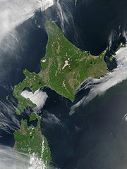
English: Satellite image of Hokkaido, Japan in May 2001. Taken from NASA's Visible Earth http://visibleearth.nasa.gov/view_rec.php?id=2060. This MODIS true-color image shows Hokkaido, Japan, at the top, and the northern tip of the island off Honshu at the bottom. Русский: Спутниковый снимок Хоккайдо (спутник Терра, NASA MODIS; май 2001 года) |
| Date | |
| Source | NASA |
| Author | NASA |
Licensing
| This file is in the public domain in the United States because it was solely created by NASA. NASA copyright policy states that "NASA material is not protected by copyright unless noted". (See Template:PD-USGov, NASA copyright policy page or JPL Image Use Policy.) | ||
 |
Warnings:
|
derivative works
Derivative works of this file: Akan volcano meakan-dake hokkaido japan space shot.jpg
| Annotations | This image is annotated: View the annotations at Commons |
Cinuyep huskoanpe
Husko cinuyep werson a=nukar kusu nea werson pácupto kik wa un=kore yan.
| 日付と時刻 | サムネイル | 寸法 | Iyeywankekur | コメント | |
|---|---|---|---|---|---|
| 現在のwerson | 2006 pam 5 2006-05-08T06:50:23+00:00up 8 312006 (Kun.) 06:50 | | 2,400 × 3,200 (466 KB) | wikimediacommons>Akanemoto~commonswiki | Satellite image of Hokkaido, Japan in May 2001. Taken from NASA's Visible Earth http://visibleearth.nasa.gov/view_rec.php?id=2060 |
Cinuyepの使用状況
以下のsosが tan cinuyep を使用しています: